
Google is releasing data on mobility related to Covid-19. From Google: “These Community Mobility Reports aim to provide insights into what has changed in response to policies aimed at combating Covid-19. The reports chart movement trends over time by geography, across different categories of places such as retail and recreation, groceries and pharmacies, parks, transit stations, workplaces, and residential.” More information on the data is available here: https://www.google.com/covid19/mobility/
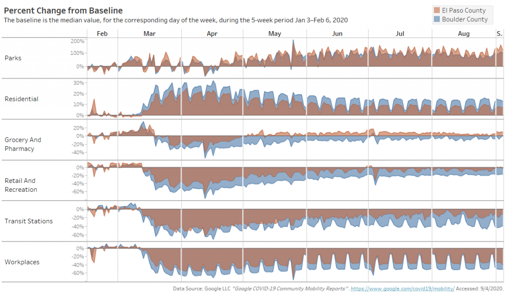
The data is available nationwide at the county and state levels. There are stock reports available from Google, but we downloaded the data and created the image below, which compares Boulder County to El Paso County. Some brief takeaways:
Boulder County to El Paso County:
- Relative to their respective baselines (established Jan. 3 – Feb. 6, 2020), residents of Boulder County have spent more time at home (the “Residential” row in the figure) than residents of El Paso County. Boulder residents have also spent relatively less time at workplaces, transit stations, retail and recreation, and grocery stores and pharmacies. The data indicates that Boulder residents have been better at quarantining than El Paso County residents.
- Residents of both counties have spent considerably more time at parks, although this is almost certainly due to the fact that the mobility baseline was established in winter.
- The political orientation of the two counties is likely influencing the mobility results for the two counties. Boulder County, which voted 70% for Clinton, the Democrat, in 2016 was much more likely to be quarantining and taking fewer trips than El Paso County, which voted 56% for Trump.